Pallay Punchu: A Complete Guide to Cusco’s Woven Mountain
 By PumAdventures
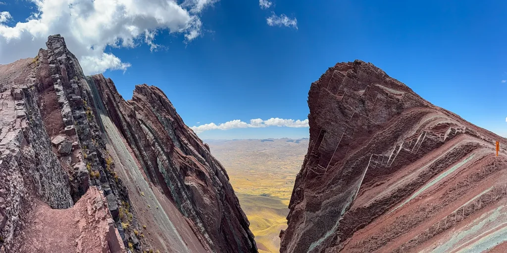
The first time most people see Pallay Punchu, it’s on a phone screen: a row of red and green blades standing almost upright, with a dark lake far below. It looks edited. It isn’t.
The mountain sits in the district of Layo, in the province of Canas, about four hours south-east of Cusco. Until 2020 it was a hillside that shepherds and herb collectors walked across and nobody photographed for strangers. Now it’s the third of Cusco’s “rainbow mountains”, and in May 2026 it appeared on a Viajes National Geographic list of the world’s most spectacular coloured mountains.
We run a two-day Pallay Punchu and South Valley tour, so take what follows with that in mind. We’ve tried to write the guide we wish we’d been handed before our first visit. That means the altitude figures nobody agrees on, the part of the ridge where people actually get hurt, what the name really means, who owns the ground you’re walking on, and when a cheap day trip is the better choice than our tour.
Table of Contents
Pallay Punchu at a Glance
| Location | Layo district, Canas province, Cusco region |
| Distance from Cusco | About 190 km by road, roughly 4 hours each way |
| Trailhead (short route) | About 4,570 m |
| Ridge and viewpoints | Roughly 4,700–4,790 m, depending on where you stop |
| Walk (short route) | 30–60 minutes up, a bit over 2 km round trip |
| Walk (long route from Layo) | 2 hours or more each way |
| Difficulty | Short walk, steep, at high altitude, exposed at the top |
| Best months | May to October |
| Entry | Community fee, reported at 10–20 soles |
| Other names | Pallay Poncho, Pallay Puncho, Apu T’aqllo, Cóndor Sayana |
What Pallay Punchu Actually Is
Pallay Punchu is a ridge of sedimentary rock that has been tilted until its layers stand nearly on edge. Wind and rain have worn those layers into narrow fins, so the colours run in sharp vertical bands rather than the soft horizontal stripes you see at Vinicunca. People who have been to both usually say the same thing: Vinicunca is a painted hillside, and Pallay Punchu looks like a saw blade.
The ridge belongs to a larger massif known locally as Apu T’aqllo. That’s why you’ll see the full name Pallay Punchu del Apu T’aqllo on community signs and in Peruvian press. One section of the ridge is called Cóndor Sayana, roughly “where the condor stands”. It gets its name from a rock point that juts out over the drop.
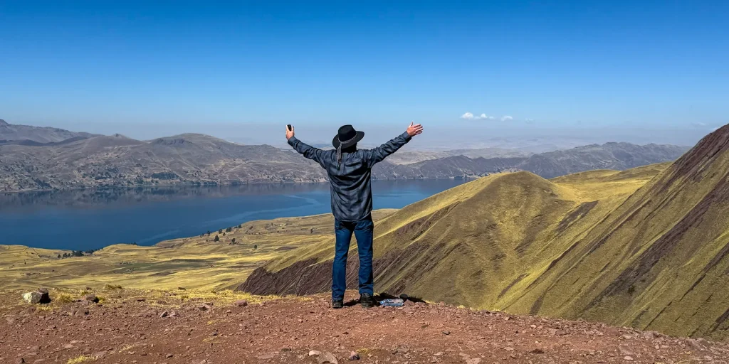
Below it all is Laguna Langui-Layo, one of the largest lakes in the Cusco region. The village of Layo sits on its shore at just under 4,000 m, and the dark water against the red rock is half of what makes the view.
Was it really “discovered” in 2020?
You’ll read that Pallay Punchu was discovered during the COVID-19 lockdown. That’s true in a narrow sense, and it gets told in a slightly misleading way.
The version you’ll hear most is that in April 2020 Tony Ccalta, a young man from the area, climbed the slope looking for sasawi, a plant his family uses for respiratory complaints. He photographed the ridge and posted the pictures, and they spread far faster than anyone in Layo expected. When the story reached the regional press, Layo’s mayor at the time, Aurelio Cáceres, described it as a discovery made by local people themselves and asked authorities and businesses to plan for visitors together.
That’s the part worth holding on to. The mountain wasn’t hidden from the people who live under it. They graze alpacas on its flanks and collect plants there, and they had names for it long before Instagram did. What changed in 2020 was that outsiders started to look. Travel writers who call it “Peru’s secret mountain” are describing their own industry, not Layo.
What Does Pallay Punchu Mean?
Most guides translate the name as “decorated poncho” or “woven poncho” and leave it there. The real meaning is better than that.
Punchu is simply the Quechua form of poncho. Spanish speakers often write the name as Pallay Poncho, and both spellings point to the same place.
Pallay is the interesting word. Its everyday meaning is “to pick up” or “to gather”, the same verb used for harvesting potatoes or picking up fallen grain. Weavers use it for something specific. On a backstrap loom, the weaver picks up chosen warp threads by hand to make a pattern appear, and that technique, along with the designs it produces, is called pallay.
So pallay punchu doesn’t just mean “a colourful poncho”. It means a poncho whose designs were picked out thread by thread. Local people looked at a ridge of vertical red, green and ochre bands and saw the patterned stripes of a hand-woven textile, the kind still made in communities across Canas and in places like Chinchero, where the Center for Traditional Textiles of Cusco has spent three decades documenting these techniques.
In Andean textiles, pallay designs aren’t decoration for its own sake. Particular motifs belong to particular communities, and many carry ideas about the land, the seasons and the pairing of opposites. Naming a mountain after one is a very Andean way of saying the landscape and the cloth are made of the same stuff.
Why the Colours Look the Way They Do
The short version: layers of sediment laid down over a very long time, rich in different minerals, later folded and pushed up as the Andes rose, then exposed to air and water.
Reds, pinks and ochres come mainly from iron compounds oxidising, which is essentially rust. Greens and blue-greens come from other minerals in the rock. Geologists will argue about exactly which ones at this site, and you’ll find tour pages naming copper, magnesium or chlorite with more confidence than we’d give them. Pale and white bands are usually sandstone or quartz-rich layers.
You’ll often see the formation dated to about 250 million years. Several operators repeat that figure, and we haven’t been able to trace it to a published geological study, so treat it as a ballpark rather than a fact.
What is clear is what makes Pallay Punchu different from its neighbours: the angle. At Vinicunca the layers lie closer to horizontal and show as stripes across a slope. At Pallay Punchu they’ve been rotated almost vertical, so erosion carves them into thin, steep crests. That geometry is why the place photographs so dramatically, and also why it needs more care underfoot than its short distance suggests.
Do the colours change through the year?
Yes, a little. When the rock is slightly damp after rain, the colours look deeper and more saturated. Under a hard midday sun in July they can look washed out in photographs, even though they’re vivid to the eye. Light cloud is your friend. Heavy cloud, which is common from December to March, can hide the ridge entirely.
Pallay Punchu Altitude: Why Every Figure Is Different
Search for the Pallay Punchu altitude and you’ll find numbers from about 3,960 m to 5,700 m. Both ends are wrong, and most of the confusion has a simple cause: people measure different points.
Here’s how the numbers fit together:
- Layo village and the lake shore: just under 4,000 m. Some articles quote the peak at “about 13,000 feet”, which is roughly this height. That figure is the village, not the mountain.
- Trailhead for the short route: around 4,570 m. This is where most vehicles stop.
- First main viewpoint on the ridge: around 4,700 m. This is the figure Peru’s state news agency, Andina, uses, and it’s the safest number to plan around.
- Highest points along the crest: quoted between about 4,730 m and 4,790 m.
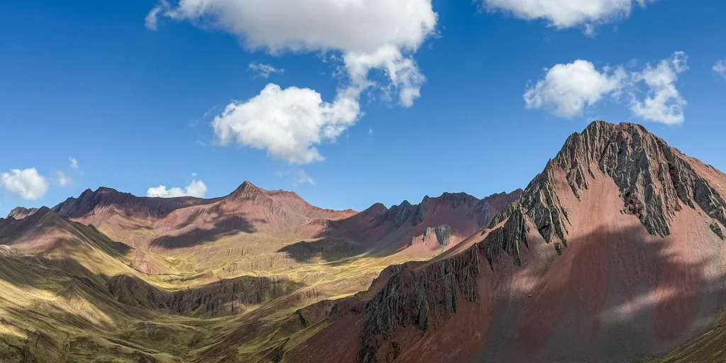
Plan for 4,700–4,800 m. That’s lower than Vinicunca, which sits at 5,036 m or more depending on the viewpoint, and a bit lower than Palccoyo at around 4,900 m. But “lower than Vinicunca” is not the same as “low”. It’s still well over 1,300 m above Cusco, and higher than any point on the classic Inca Trail.
The figure that matters most for your body isn’t the summit, though. It’s how quickly you get there. On a standard day trip you leave Cusco at 3,400 m around 4 AM and can be standing at 4,700 m by about 10 AM, after four hours of sitting still in a van. That’s a fast climb for a body that may have arrived in the Andes two days earlier.
How to Get to Pallay Punchu from Cusco
The road
Every route starts south-east of Cusco along the Vilcanota valley, the road that eventually continues to Puno and Lake Titicaca. You pass Urcos, Cusipata and Checacupe, reach the market town of Sicuani at about 3,550 m, then turn off and climb towards Layo and the lake. The final stretch to the trailhead is a dirt road.
Total distance is about 190 km each way. Allow four hours from Cusco on a good day. Road works on the Cusco–Sicuani highway and the dirt section after Layo can both add time, especially in the wet season.
Option 1: Group day trip
This is how most people go. You’re picked up around 4:00–5:00 AM, with breakfast in Cusipata or Layo, the hike mid-morning, lunch in Layo (lake trout is the local speciality), and you’re back in Cusco around 6 PM. Expect 12 to 15 hours door to door, about eight of them in a vehicle.
Group prices on the big booking platforms start at around US$40–90, with the community fee sometimes included and sometimes not. Private day trips run from roughly US$150 to US$290 per person. If you’re well acclimatised, on a budget and don’t mind a long day, a reputable group trip is a perfectly sensible choice.
Option 2: Two days, sleeping in Sicuani
This is the format we chose for our own Pallay Punchu and South Valley tour, and it’s worth explaining why.
On day one you travel south slowly, stopping at Tipón (around 3,450 m), the Wayki museum in Andahuaylillas and the Inca site of Raqchi, with its great wall to the god Wiracocha and its rows of round storehouses. You sleep in Sicuani. On day two you have breakfast at 7 AM, drive about an hour to the trailhead, and you’re walking while most day-trippers are still on the road.
What this buys you:
- No 4 AM start. You arrive at altitude rested rather than stiff and underslept.
- Half the driving on hike day. That matters more than people think for nausea and headaches.
- Your first day at Cusco-like altitude. The South Valley sites sit at roughly the same height as Cusco, so day one isn’t asking anything extra of your body.
- Context. Raqchi and Tipón turn a photo stop into a day that makes sense of the region.
What it costs: more money and an extra day. Prices start at US$560 per person for two travellers and come down as the group grows. The full table, inclusions and current dates are on the tour page. We’d rather you book the format that suits you than the one that suits us.
Option 3: On your own
It can be done. Take a bus from Cusco to Sicuani, then a colectivo or taxi to Layo, then either walk the long route or hire a local driver up the dirt road. Mobile signal is patchy, there are no services at the trailhead, and if the weather turns you’re on your own at 4,700 m. If you go independently, tell someone your plan, carry cash for the community fee, and turn around early if anything feels wrong.
The Hike: Short, Steep and Exposed
Here’s what the walk is actually like, because “easy hike” and “moderate” both undersell one part of it and oversell another.
The short route (what most tours do)
From the trailhead at about 4,570 m, a gravel path zigzags up a grassy slope. It’s not technical. It is steep enough that at this altitude most people stop every few minutes, and you’ll hear your own breathing in a way you probably haven’t since you were a child. Expect 30 to 60 minutes to the first viewpoint, depending on your lungs rather than your legs.
The first viewpoint is the one in most photographs: the coloured fins in the foreground, the lake below, the high puna rolling away towards Puno. Many people stop here, and that’s a perfectly good place to stop.
From there a narrower path follows the crest to other viewpoints, including Cóndor Sayana. There’s no single summit to “bag”. You move along the ridge and the view changes with every few metres.
The long route from Layo
Some operators walk up from the village area through grazing land rather than driving to the trailhead. It’s longer, from about two hours each way to considerably more depending on the start point, and much quieter. You’ll pass herders and alpacas and see the ridge come into view gradually rather than all at once. It’s a lovely walk if you’re well acclimatised. It’s a poor choice on your third day in Peru.
Where people get hurt
Not on the way up. On the ridge.
The crest is made of the same thin, eroded rock that makes it beautiful. Some fins are only a few metres wide, the surface is loose gravel over hard rock, and the drop on either side is long. Add a wind that can gust hard across the ridge by late morning, and a camera held at arm’s length, and you have the real hazard.
Our honest rules for the crest:
- Stay on the worn path. It exists because it’s the stable line.
- Don’t walk out onto a narrow fin for a photo. The best picture is almost always from slightly back, where the ridge and lake are both in the frame anyway.
- Stop moving when you take a photo. Walking and filming at 4,700 m is how ankles turn.
- Hold onto hats and phones in gusts, and crouch rather than stand tall if the wind picks up.
- Use trekking poles on the descent. Loose gravel is worse going down than up.
- Get off the ridge if you hear thunder. In the wet season, afternoon storms build quickly, and a high, exposed crest is the last place to be.
If heights bother you, you can still have a wonderful visit. Stay at the first viewpoint, which is broad and safe, and let your guide take your phone along the crest if you want that shot.
Altitude: What to Watch For
Pallay Punchu is lower than Vinicunca, and many tour pages say altitude sickness risk is “lower” here. That’s true in the same way a 4,700 m mountain is safer than a 5,000 m one: slightly. The main risk factors are still in play, especially how soon after arrival you go and how fast you climb.
Acclimatise first. Give yourself at least two or three full days in Cusco or the Sacred Valley before you go. Three or more is better, and our own tour page recommends three. If you’ve done another high excursion first, such as Palccoyo, Humantay Lake or a few days of walking, so much the better.
Common, usually mild symptoms: headache, nausea, poor appetite, dizziness, unusual tiredness, breathlessness on effort, and poor sleep the night before. Mild symptoms often settle with rest, water and a slower pace.
Warning signs that mean you go down, now:
- A headache that doesn’t ease with rest or simple painkillers
- Vomiting
- Confusion, slurred speech, or stumbling as if drunk
- Breathlessness while resting
- A persistent cough, especially if it’s wet or gurgling
- Bluish lips or extreme fatigue
These can be early signs of serious altitude illness. Tell your guide straight away. Descending, even a few hundred metres, is the treatment that works. Our tours carry a first-aid kit and oxygen, but oxygen buys time to get down. It doesn’t replace getting down.
Talk to a doctor before the trip if you have heart or lung disease, high blood pressure, anaemia or sickle-cell trait, have had altitude illness before, are pregnant, or take regular medication. Ask your doctor, not a tour agent, about preventive medicines such as acetazolamide.
Coca tea is everywhere in Cusco and many people find it pleasant at altitude. It’s part of daily life here and has been for centuries. It is not a substitute for acclimatisation or medical care.
Finally, check your travel insurance covers hiking up to 5,000 m. Many standard policies stop at lower altitudes or exclude “trekking” unless you add it.
Pallay Punchu vs Vinicunca vs Palccoyo
Our Rainbow Mountain guide compares all three in detail. Here’s the short version, from Pallay Punchu’s side.
| Pallay Punchu | Vinicunca | Palccoyo | |
| Highest point usually reached | ~4,700–4,790 m | ~5,036 m+ | ~4,900 m |
| Drive from Cusco | ~4 h | ~3 h | ~3 h |
| Walk (standard route) | 30–60 min up, short | ~1.5–2 h up, about 4 km each way | ~40 min, gentle |
| Terrain | Steep path, exposed crest | Long climb, steep final section | Broad, gentle ridges |
| Look | Vertical fins and a lake | One classic striped slope | Three softer coloured ridges |
| Crowds | Few | Many, often hundreds or more | Few |
| Horse available | Sometimes, by arrangement with the community | Yes, widely | Limited |
Choose Pallay Punchu if you want drama and very few people, and you’re comfortable on a short, steep, exposed walk. It’s also the one to pick if you’ve already seen photos of Vinicunca so often that the real thing might disappoint.
Choose Vinicunca if the classic striped slope is the image you came for and you’re well acclimatised and fit.
Choose Palccoyo if you want colour with the least effort and the least exposure. It’s the kindest option for older travellers or anyone nervous about heights.
Can you do Pallay Punchu instead of Vinicunca? Yes, if what you want is a coloured mountain without the crowds. If what you want is that photograph, the one from the posters, then no. They’re genuinely different places.
When to Visit Pallay Punchu
May to October (dry season) is the most reliable time. Mornings are clear, the dirt road is in better condition and storms are rare. June and July bring cold, sharp mornings, often below freezing at dawn, and sunny days. May, September and October are our favourites: good weather and fewer travellers in the region.
November to March (wet season) brings cloud, rain, hail and occasional snow on the ridge. The colours can be at their richest when the rock is damp and the hills around are green. The trade-off is a real chance of seeing nothing at all, slippery paths on the crest, afternoon lightning, and a road that can turn to mud after Layo. January and February are the riskiest months.
Time of day: morning, every time. The light is softer, the wind usually hasn’t built yet, and wet-season storms tend to arrive in the afternoon. This is another quiet advantage of sleeping in Sicuani.
Wind: expect it in any month, usually stronger from late morning. It’s colder on the ridge than the number on your weather app suggests.
What to Bring
The basics, adjusted for this particular mountain:
- Layers. A warm base layer, a fleece or light down jacket, and a windproof or waterproof shell. Dawn can be below zero, and the sun can be fierce by 11 AM.
- Hat, gloves and a buff for the wind on the crest.
- Sun protection. High-factor sunscreen, sunglasses and lip balm. UV at 4,700 m burns faster than you expect.
- Proper hiking shoes with grip. Loose gravel and trainers are a bad combination.
- Trekking poles for the descent. Our tour includes them.
- Water, at least a litre and a half, and some snacks.
- Cash in small soles for the community fee if it isn’t included, toilets, a drink in Layo or a textile you might want to buy.
- Your passport or a copy. Some checkpoints and hotels ask for it.
- Any medication you take, plus whatever your doctor advised for altitude.
Drones are a sensitive subject in rural communities, and grazing animals panic when one flies overhead. Ask your guide and the community before you fly anything.
The Community, the Fee and the Ground Under Your Feet
Pallay Punchu isn’t a national park with a ticket office run from Lima. It’s on land used and looked after by communities in the Layo area, and access is managed locally. You’ll pay a community fee at the control point. Reports and operator pages put it somewhere between 10 and 20 soles per person, and it has changed since the site opened. Our tour includes it. If you go independently, carry cash.
That fee is one of the few ways the people who live here earn directly from the view. So are breakfast and lunch in Layo, horses hired from local families, and textiles bought from the women who sometimes sell near the trailhead. If you’re choosing between operators, it’s fair to ask where they eat and whether they use local guides or horsemen.
A few things that matter here more than at a busier site:
- Take every piece of rubbish back down, including fruit peel and tissue. Nothing decomposes quickly at this altitude.
- Stay on paths, both on the ridge and on the grazing slopes. The grass is pasture for someone’s animals.
- Ask before photographing people. Children in particular, and herders working with their animals.
- Don’t build stone cairns or leave objects on the ridge. Stone piles in the Andes, apachetas, have meaning, and visitors building their own is a little like a stranger rearranging a shrine.
- Give way to animals and the people herding them.
Is Pallay Punchu Sacred?
This is where we’ll disappoint some readers, on purpose.
In Andean understanding, the great mountains are Apus, living presences that watch over the communities below them. Our article on the Apus, the Andean mountain spirits goes into this properly. The name Apu T’aqllo tells you that the massif is regarded that way locally, and families in Canas make offerings to their mountains, as people do across the southern Andes.
What there isn’t, as far as we know, is any archaeological or historical evidence that the coloured ridge itself was an Inca pilgrimage site or a ceremonial centre. Some tour pages imply it was. We think that does a disservice to both the mountain and the culture. The colours became famous in 2020, and the reverence for the Apu is much older and has little to do with how photogenic it is.
If you’d like to mark your visit in a way that fits the place, ask your guide about making a k’intu: three coca leaves held together, a quiet intention breathed into them, and the leaves left at the ridge or given to the guide to place. It takes two minutes and is common practice among people who live here. It’s the same gesture at the heart of a despacho offering, and it’s a gesture of respect, not a ceremony you’re performing. Don’t let anyone sell you a “shamanic summit ritual” at the trailhead.
If ceremony is what you’re really after, it’s better done properly and somewhere else. A coca leaf reading in Cusco, with a paqo who has time for you, is a far better setting than a windy ridge with a van waiting.
Who Should — and Shouldn’t — Do Pallay Punchu
It’s a great fit if you:
- Have spent at least two or three days at altitude and feel well
- Want a coloured mountain with very few other visitors
- Are steady on your feet and comfortable with some exposure
- Like photography and are happy to give a place time rather than rush it
Think twice, or choose differently, if you:
- Arrived in Cusco yesterday or the day before
- Have a heart or lung condition, high blood pressure, or are pregnant, unless your doctor has cleared it
- Have strong vertigo. Palccoyo is the gentler choice.
- Are travelling with small children. Some operators set a minimum age around five, and even then the crest is no place for a child who runs.
- Get badly carsick. Eight hours of road in one day is hard, and if this is you, the two-day format helps a lot.
Mistakes We See
Booking it for day two in Cusco because the hike is “only 30 minutes”.
Trusting the lowest altitude figure. The 13,000 ft number is the village, not the ridge.
Walking out onto a narrow fin for a photograph, in the wind, with a phone in one hand.
Wearing trainers on loose gravel.
Going in February and spending eight hours in a van to look at a cloud.
Assuming “no crowds” means “no rules”. It’s someone’s pasture and someone’s Apu.
Forgetting cash for the community fee.
Frequently Asked Questions About Pallay Punchu
Where is Pallay Punchu?
In the district of Layo, province of Canas, in the south of the Cusco region, above Laguna Langui-Layo. It’s about 190 km from Cusco by road, roughly four hours each way.
How high is Pallay Punchu?
The main viewpoint is at about 4,700 m (15,420 ft). Higher points along the crest are quoted at 4,730–4,790 m. The short-route trailhead sits around 4,570 m.
What does Pallay Punchu mean?
Punchu is Quechua for poncho. Pallay means “to pick up” and, in weaving, refers to the pick-up technique and the patterns it creates. Together it means a poncho with hand-picked woven designs, which is what the vertical coloured bands look like. It’s also spelled Pallay Poncho.
How long is the hike?
On the short route, 30–60 minutes up to the first viewpoint and a bit over 2 km round trip, plus time along the ridge. Longer routes from near Layo take two hours or more each way.
Is Pallay Punchu harder than Vinicunca?
Usually easier overall: lower, much shorter, and far less crowded. But the crest is narrower and more exposed than anything at Vinicunca, so it asks more of your balance and your head for heights.
Is it safe?
For acclimatised, reasonably fit people who stay on the path and respect the weather, yes. The main risks are altitude illness and falls on the exposed ridge, especially in wind or wet conditions. There’s no medical help at the site, and the nearest hospital is in Sicuani.
How many days should I acclimatise before going?
At least two or three full days in Cusco or the Sacred Valley, ideally three or more. More is always better.
Is there an entrance fee?
Yes, a community fee paid at the control point, reported between 10 and 20 soles per person. It’s included in our tour.
Can I visit Pallay Punchu without a tour?
Yes. Take a bus to Sicuani, then local transport to Layo and either walk or hire a driver to the trailhead. Signal is patchy and there are no services at the site, so go prepared and tell someone your plans.
When is the best time to visit?
May to October, in the morning. The wet season (November to March) can be beautiful but often brings cloud, storms and muddy roads.
Can I ride a horse?
Sometimes, by arrangement with local families, but it’s not set up the way it is at Vinicunca. Ask your operator in advance rather than counting on it.
Can I combine Pallay Punchu with other sites?
Yes. Raqchi, Tipón, Andahuaylillas and the Checacupe bridges are all on or near the road south. Our two-day tour includes Tipón, the Wayki museum and Raqchi. The famous Q’eswachaka rope bridge, rewoven by hand every June and recognised by UNESCO, is also in Canas province, but it’s on a different road and isn’t part of our standard itinerary.
Is Pallay Punchu a sacred site?
The massif, Apu T’aqllo, is regarded locally as an Apu, a protective mountain spirit. There’s no evidence the coloured ridge was an Inca ceremonial site, and we’d be wary of anyone selling it as one.
What We’d Actually Tell You
If you’ve been in Cusco for four or five days, you feel good, and the idea of a striped mountain with almost nobody on it appeals more than the famous one, go to Pallay Punchu. Go in the dry season, go in the morning, stay on the path along the crest, and take a minute at the first viewpoint before you rush for the next photo. The lake is worth looking at without a screen in front of it.
If you’ve only just arrived, give it a few days. The mountain has been there a long time and will wait.
And if you’d rather not spend eight hours in a van on hike day, our Pallay Punchu and South Valley tour breaks the trip into two easier days, with Raqchi and Tipón along the way and a night in Sicuani before the climb. If it’s not the right fit for you, we’ll tell you so. You can see our other treks and day hikes here, or read our guide to choosing the right trek in Cusco.
Last checked: November 2026. Community fees, road conditions and access rules at Pallay Punchu change from season to season. Confirm the details with your operator before you travel.
Further reading: Andina’s coverage of Pallay Punchu’s inclusion among the world’s most spectacular rainbow mountains, and the Center for Traditional Textiles of Cusco on the weaving tradition behind the name.