Rainbow Mountain: Vinicunca, Palccoyo or Pallay Punchu?
 By PumAdventures

Most people searching for Rainbow Mountain Peru don’t know there are three of them.
They book Vinicunca, because Vinicunca is the one on Instagram. They book it for their second or third day in Cusco, because the tour is advertised as a full-day excursion and full-day excursions are what you do early in a trip. And a meaningful number of them spend that day being sick at five thousand metres.
The single number that should reorder this whole decision: Vinicunca’s summit is commonly given as 5,036 m, with some sources putting the highest viewpoint at up to 5,200 m and our own tour listing 5,020 m at the mountain. The exact figure varies. What doesn’t vary is that you are above five thousand metres, on a day trip, from a city at 3,399 m.
Marketed as moderate. It isn’t.
The good news is that two alternatives exist, both lower, both emptier, and one of them barely known. This article covers all three honestly — the numbers, the walk, the crowds — plus the altitude conversation nobody has with you at the point of sale, and the genuinely surprising truth about how old this “sacred mountain” actually is.
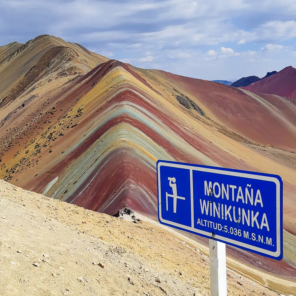
Table of Contents
The Three at a Glance
| Vinicunca | Palccoyo | Pallay Punchu | |
| Summit / viewpoint | ~5,036 m (sources vary to 5,200 m) | ~4,900 m | ~4,700–4,800 m |
| Trailhead | ~4,600–4,900 m | ~4,900 m | Near the top |
| Walk each way | ~4 km, 1–1.5 h | ~3 km circuit, 45 min–1 h | 45 min–1 h from parking |
| Drive from Cusco | ~3 h | ~3 h | ~4 h |
| Crowds | Very high | Low | Low |
| Difficulty | Challenging | Moderate | Moderate–challenging |
| Shape | One striped ridge | Three coloured ridges | Jagged “poncho” peaks |
| Extra | Red Valley nearby | Stone forest | Views over Lake Langui |
The three hundred metres between Vinicunca and Palccoyo are not cosmetic. At this altitude, 300 m makes a real physiological difference — less breathlessness, slower onset of fatigue, and a meaningfully lower chance of your day going wrong.
Vinicunca — The Famous One
What you’re signing up for
A 4 AM pickup. Roughly three hours on the road through the South Valley. Breakfast somewhere en route. Then the walk in from the Llacto trailhead — around four kilometres, an hour to an hour and a half each way, with the final ascent to the viewpoint steep enough that plenty of people stop repeatedly in the last two hundred metres.
Back in Cusco around five in the afternoon. A thirteen-hour day for about three hours of walking, most of it above 4,600 m.
Why it’s worth it, honestly
Because it is genuinely spectacular. The striped ridge is not a filter — the bands really are that saturated in the right light, and standing on that col with Ausangate at 6,384 m filling the southern horizon is one of the great views in the Andes.
Our Rainbow Mountain and Red Valley hike adds the Red Valley next door at about 4,762 m, which most people end up preferring: deep rust-coloured slopes, no queue, and almost nobody there.
The crowds are real
Vinicunca receives well over a hundred thousand visitors a year. From around 9 AM in high season the col is genuinely busy — a queue for the photograph, drones, horses, vendors.
Go early. The 4 AM start is not sadism; it’s the only way to be at the viewpoint before the volume arrives.
Who it suits
Fit travellers who have already spent three or more nights at altitude, who don’t have cardiac or respiratory conditions, and who want the specific image.
Everyone else should read the next two sections before booking.
Palccoyo — The Sensible One
The alternative we recommend most, and the one that converts sceptics.
Around 4,900 m at its highest point — and critically, the trailhead sits at almost the same height. Which means a walk of three kilometres on a gentle circuit, forty-five minutes to an hour to the viewpoints, on ground that never gets seriously steep.
The same three-hour drive from Cusco. And where Vinicunca gives you one striped ridge, Palccoyo gives you three, spread across a wide valley, plus a “stone forest” of eroded rock pillars nearby.
The crowds are a fraction of Vinicunca’s. On a weekday outside peak season you may share the ridge with a handful of people.
Who it suits: anyone with limited acclimatisation, anyone travelling with children or older parents, anyone with knee problems, anyone who wants the colour without the suffering — and, frankly, anyone who would rather look at three coloured ridges in near-solitude than queue for one.
The trade: it is less dramatic. The single ridge at Vinicunca is more striking than any one of Palccoyo’s three, and if you’ve seen the photograph and that photograph is what you want, Palccoyo won’t produce it.
Pallay Punchu — The New One
The third option, and still largely unknown.
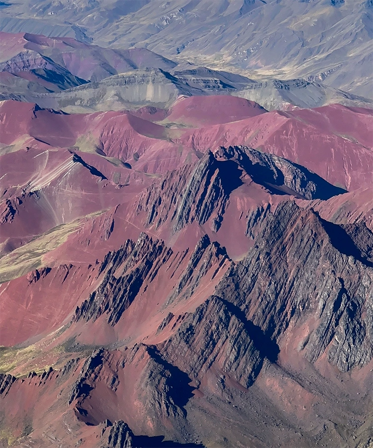
Pallay Punchu de Apu T’acllo sits at roughly 4,700–4,800 m in Canas province, in the far south of the Cusco region. It is a ridge of jagged, blade-like peaks striped in colour — the name means something close to “woven poncho,” and the resemblance to a folded Andean textile is the whole point.
It was effectively discovered during the COVID lockdown in April 2020, which makes it the newest attraction in the region by a wide margin.
The logistics are the catch. About four hours from Cusco each way, which makes for a very long day. From the parking area the walk is short — forty-five minutes to an hour — though it’s steeper than Palccoyo. Starting from Layo village instead turns it into a three-hour-plus ascent.
What you get that the others don’t: the views over Lake Langui-Layo from the ridge, and near-total solitude.
Who it suits: people on a second visit to Cusco, photographers, and anyone who would trade two extra hours in a van for having a mountain to themselves.
Rainbow Mountain Peru: Which One Should You Book?
| If you… | Book | Why |
| Have 3+ nights at altitude and want the photo | Vinicunca | The iconic ridge, and Ausangate behind it |
| Arrived in Cusco two days ago | Palccoyo | 300 m lower and a far gentler walk |
| Are travelling with children or older parents | Palccoyo | Short, flat-ish, low stress |
| Have had any altitude trouble already | Palccoyo, or neither | See the next section |
| Have knee or mobility problems | Palccoyo | The shortest walk of the three |
| Hate crowds above everything | Pallay Punchu | Almost nobody goes |
| Are on a second trip to Cusco | Pallay Punchu | Something genuinely new |
| Have a cardiac or respiratory condition | None, without medical clearance | 5,000 m is a serious ask |
| Want the colour and the emptiness | Palccoyo | The best balance of the three |
Our honest default for first-time visitors is Palccoyo — and we say that knowing Vinicunca is the one people arrive asking for. If you have the acclimatisation and the fitness, take Vinicunca and go early. If you’re uncertain about either, Palccoyo will give you a better day.
The Altitude Conversation Nobody Has With You
This is the section the booking pages leave out, and it matters more than anything above.
What you are actually doing
Cusco sits at 3,399 m. Vinicunca’s viewpoint is above 5,000 m. You gain more than 1,600 metres in a single morning and stand at an altitude where the air holds roughly half the oxygen available at sea level.
The only reason this is routine rather than reckless is that you don’t sleep up there — you go up, you come down. But altitude illness does not wait for bedtime, and standard guidance on gradual ascent, such as the CDC’s high-altitude travel recommendations, exists precisely because gains of this size are not trivial.
Acute mountain sickness: what it feels like
Headache, nausea, loss of appetite, dizziness, fatigue out of proportion to the effort, and difficulty sleeping. Symptoms typically appear within two to twelve hours of reaching altitude.
Mild AMS is common on this trip and usually resolves on descent. The problem is that people push through it — they have paid, they have driven three hours, and the viewpoint is only twenty minutes further.
On this mountain, pushing through is the wrong instinct.
The signs that mean go down now
Not later. Not after the photograph.
- Worsening headache that painkillers don’t touch
- Vomiting repeatedly
- Confusion, slurred speech, or difficulty walking in a straight line
- Breathlessness at rest, rather than on exertion
- A cough producing frothy or pink sputum
- Blue-tinged lips or fingertips
The last three suggest HAPE or HACE — high-altitude pulmonary or cerebral oedema. Both are life-threatening, both can develop rapidly, and the only reliable treatment is immediate descent. At Vinicunca that means getting back to the vehicle and losing altitude fast, with the nearest hospital three hours away.
Tell your guide the moment you feel wrong. Our guides carry a first aid kit with emergency oxygen for exactly this, and we would far rather turn a group around than complete an itinerary.
What helps, and what doesn’t
Helps: several days at altitude beforehand. Going slowly — genuinely slowly, slower than feels necessary. Drinking water constantly. Eating breakfast even without appetite. Coca tea or chewing coca, which is what the crew will be doing. Taking the horse, which is available at the trailhead for around 120 soles and carries no stigma whatsoever.
Doesn’t help: being fit. Altitude illness does not correlate with fitness — marathon runners get it and sedentary people sometimes don’t. What predicts it is acclimatisation and rate of ascent.
Also doesn’t help: alcohol the night before, sleeping pills, or arriving on no sleep from a 4 AM start after a late night.
Worth discussing with your doctor before you travel: acetazolamide, which is a prescription decision and not one any tour operator should be making for you.
Who should not do Vinicunca
Anyone with a cardiac condition, uncontrolled hypertension, or significant respiratory disease, without clearance from their own physician. Anyone in late pregnancy. Anyone with sickle cell disease. Anyone who has already had a bad time at altitude in Cusco.
For most of these travellers Palccoyo is not a compromise, it’s the correct choice — and for some, neither mountain is. That’s a legitimate outcome and we’ll say so if you ask us.
Our guide to altitude and acclimatisation for Cusco treks goes into the preparation in detail, and our 7-day Cusco itinerary shows where a day like this sensibly fits in a trip.
The Honest History: This Is Not an Ancient Sacred Site
Here’s the part that surprises people, and we’d rather you heard it from us than discovered it later.
Rainbow Mountain is new.
The geology is old — the coloured layers are Cretaceous sedimentary rock, roughly 75 to 63 million years old, lifted into place by the Andean orogeny. The bands are mineral: iron oxides for the reds, sulfur compounds in limy sandstones for the yellows, chlorite and ferro-magnesian clays for the greens, red clays and mudstones for the pinks, quartz sandstones and calcium-carbonate marls for the whites, and copper compounds for the turquoise.
But those layers were under ice. Accelerated glacial retreat in the Ausangate massif, broadly between 2010 and 2013, uncovered the coloured slopes and revealed them to local herders. The first guided treks ran from about 2013. Social media did the rest around 2016, and within a few years the mountain was receiving over a hundred thousand visitors annually.
So when an operator tells you Vinicunca was a sacred Inca pilgrimage site — it wasn’t, and it couldn’t have been. Nobody’s great-grandmother made offerings on that ridge, because that ridge was a glacier.
What is genuinely ancient is what it stands under.
Ausangate, at 6,384 m, is one of the two or three greatest Apus in the southern Andes — named in despachos across the region, and the mountain on whose flanks the Qoyllur Rit’i pilgrimage has taken place for centuries, drawing tens of thousands of people to over 4,600 m. Our pieces on the Apus and on the snow star pilgrimage cover what that actually means.
So the honest framing is this: you are standing on a young tourist attraction, looking at an ancient holy mountain. And the reason you can see the colours at all is that the ice which held this landscape for millennia is going. There is something worth sitting with in that, and it’s more interesting than an invented legend.
If the sacred mountain is what draws you, the mountain is Ausangate — reachable on our 7 Lakes day tour, which climbs to about 4,620 m, or properly on the Ausangate trek.
The Community, and Where the Money Goes
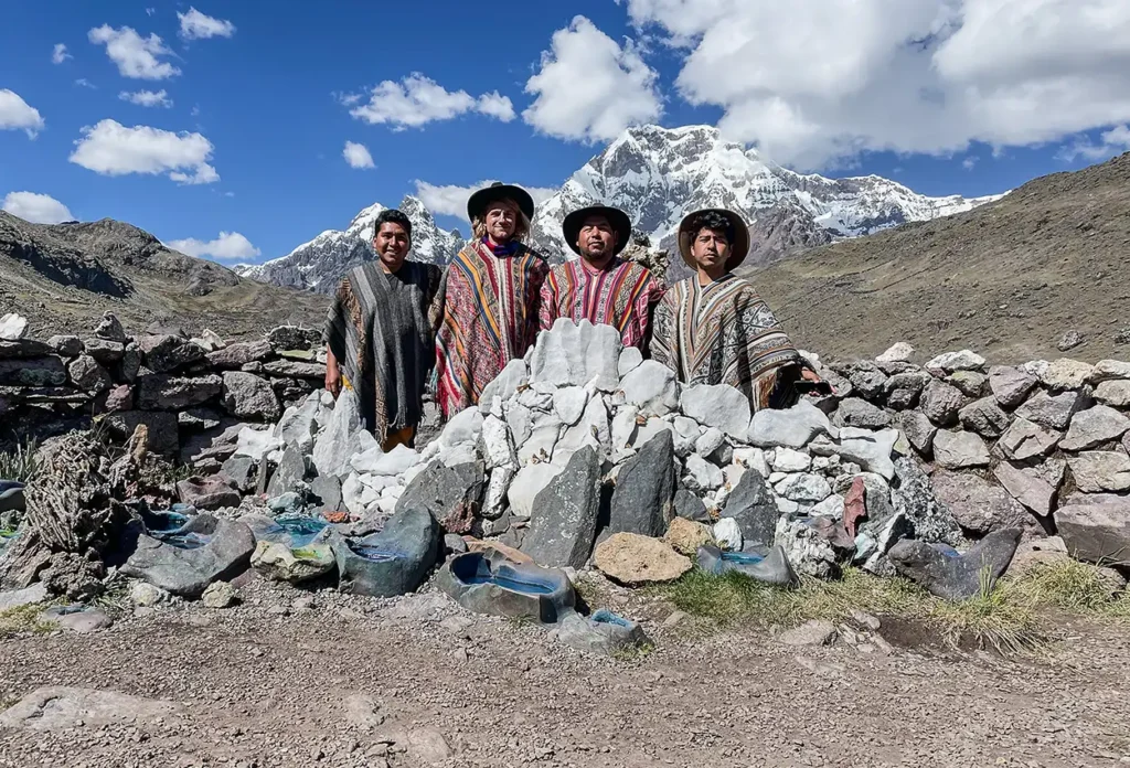
Vinicunca sits on land belonging to the communities of Pitumarca district, and the site is community-managed. The entrance fee you pay at the trailhead goes to them, as does the income from the horses, the snacks and the small stalls at the col.
Two practical consequences. Carry small soles in cash — card payment is not a thing up there. And take the horse if you need it; it supports a local household and it is the difference between finishing and turning back for a lot of people.
The same applies at Palccoyo and Pallay Punchu, both of which are managed by their own communities and both of which see a tiny fraction of Vinicunca’s income. Choosing the quieter mountain is also choosing to spread the money.
And carry your rubbish out. All three sit in fragile high-altitude terrain where nothing decomposes quickly, and Vinicunca in particular is visibly suffering from the volume.
When to Go, and What to Bring
Best months: April to October, the dry season. May, September and October give the best combination of clear skies and manageable crowds. June to August is peak — clearest weather, coldest mornings, most people.
Avoid January and February if you can. The colours are muted under cloud, the track turns to mud, and snow on the ridge hides the bands entirely. Our guide to the best time to visit Cusco sets out the seasonal picture.
What to bring:
- Layers. It is below freezing at dawn and warm by mid-morning. A down jacket, a fleece, and something to strip down to.
- Sun protection that works at 5,000 m. High-factor sunscreen, brimmed hat, real sunglasses. The UV up there is severe and people badly underestimate it.
- Gloves and a warm hat. The wind on the col is the thing that ends days.
- Poles. Available for rent at around $15 if you don’t travel with them.
- Water, more than you think. Dehydration makes altitude worse.
- Cash in small soles for the entrance, the horse and the toilets.
- Snacks. Appetite disappears at altitude; sugar helps.
What It Costs
Our Rainbow Mountain and Red Valley hike starts at $210 per person, based on two travellers, including hotel pickup at 4 AM, private transport to the Llacto trailhead, an English-speaking guide, breakfast and a box lunch, and a first aid kit with emergency oxygen.
Not included: the horse at the trailhead (around 120 soles), trekking poles ($15), and tips.
On the very cheap group tours. Rainbow Mountain is sold in Cusco from remarkably low prices, and what gets cut is exactly what matters here: group size, guide-to-client ratio, vehicle quality on a three-hour mountain road, and whether there is oxygen on board. At 5,000 m those are not luxuries. Ask specifically whether the tour carries oxygen and what the evacuation plan is. If the answer is vague, book elsewhere.
The full range of day hikes and treks is on our treks page.
Mistakes We See
Booking it for day two in Cusco. The single most common and the most consequential.
Assuming “moderate” means easy. It describes the terrain, not the altitude.
Pushing on through a headache because the viewpoint is close.
Refusing the horse out of pride.
Underdressing. People arrive in a t-shirt and a rain jacket for a 4 AM start at 4,600 m.
Booking the cheapest tour available for a trip where the vehicle and the oxygen are the product.
Going in February and being surprised the colours don’t show.
Believing the ancient-pilgrimage story. It’s marketing.
Frequently Asked Questions
How high is Rainbow Mountain in Peru?
Vinicunca is commonly given as 5,036 m, with some sources citing up to 5,200 m at the highest viewpoint. Palccoyo is around 4,900 m and Pallay Punchu 4,700–4,800 m.
Is Rainbow Mountain hard?
Vinicunca is challenging — around 4 km each way with a steep final section, all above 4,600 m. Palccoyo and Pallay Punchu are considerably easier.
Vinicunca or Palccoyo?
Vinicunca for the iconic ridge if you’re acclimatised and fit. Palccoyo for almost everyone else: lower, shorter, emptier, three ridges instead of one.
What is Pallay Punchu?
A third rainbow mountain in Canas province at roughly 4,700–4,800 m, effectively discovered in April 2020, with views over Lake Langui and very few visitors. Four hours from Cusco.
How do I avoid the crowds at Rainbow Mountain?
Take the earliest departure, travel outside June–August, or choose Palccoyo or Pallay Punchu instead.
How many days should I acclimatise first?
Three nights at altitude minimum before Vinicunca. Two may be enough for Palccoyo, but more is always better.
Can I ride a horse up?
Yes, at Vinicunca, for around 120 soles arranged at the trailhead. It supports a local family and there is no reason not to.
Is Rainbow Mountain a sacred Inca site?
No. The colours were exposed by glacial retreat around 2010–2013. Ausangate, the great peak behind it, is genuinely one of the region’s most important Apus.
What’s the best month to go?
May, September or October for the best balance of weather and crowds. Avoid January and February.
What if I get altitude sickness?
Tell your guide immediately and descend. Do not push on toward the viewpoint.
What We’d Actually Tell You
If you have been in Cusco for four days, you feel fine, and the striped ridge is the image you have carried around for years — book Vinicunca, take the first departure, walk slowly, and take the horse if you need it.
If you arrived the day before yesterday, or you’re travelling with your parents, or you already felt rough walking uphill in San Blas — book Palccoyo. Three coloured ridges, forty minutes of gentle walking, and hardly anyone there. You will not spend the afternoon regretting it.
And whichever you choose, look south. The mountain worth knowing about is the enormous white one behind you, and people have been making offerings to it for a very long time.
Tell us your dates and how long you’ll have been at altitude, and we’ll tell you honestly which of the three — if any — is right for your trip.
Altitudes for all three mountains vary between published sources and are given here as ranges where they conflict; treat them as approximate. High-altitude travel carries a real risk of acute mountain sickness, HAPE and HACE regardless of fitness, and these conditions can be fatal. This article is general information and not medical advice — consult your physician before travelling above 3,000 m, particularly with any cardiac, respiratory, blood-pressure or haematological condition, or if pregnant. General altitude guidance referenced from the CDC Yellow Book. Protected areas in the region are administered by SERNANP; cultural heritage by the Ministerio de Cultura. All three sites are community-managed and access arrangements can change.