Cusco’s Sacred Sites on Foot: A Walking Route With Meaning
 By PumAdventures
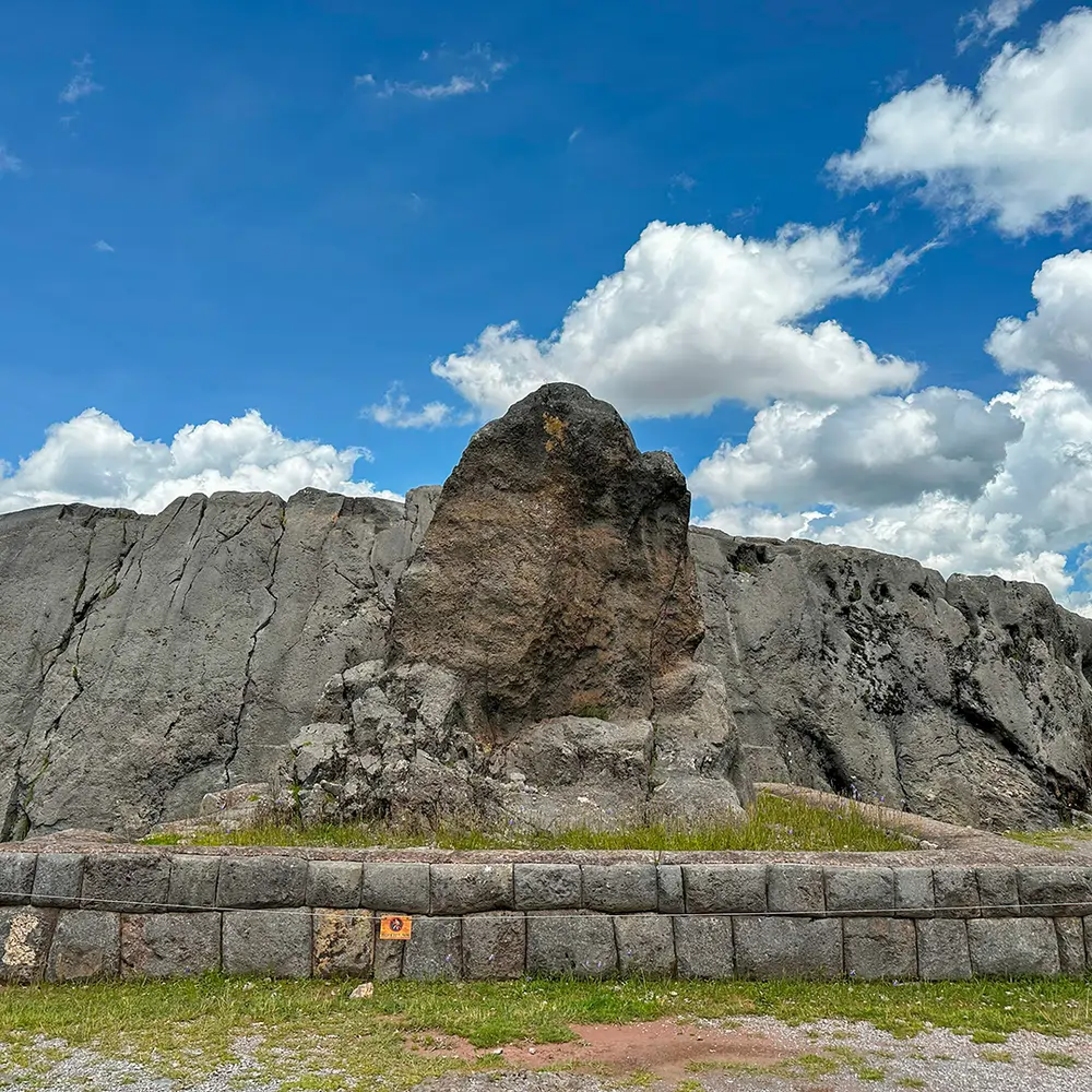
Cusco Sacred Walk – Coricancha, Sacsayhuamán, Q’enqo and Tambomachay: a half-day walking route through Cusco’s temples, in the order that actually makes real sense.
The standard Cusco city tour puts you in a minibus, drives you to four archaeological sites in three hours, tells you Sacsayhuamán means “satisfied falcon,” and returns you to the Plaza de Armas having explained almost nothing about how the places relate to each other.
They do relate. Precisely, and by design.
Everything above Cusco was organised as part of a single system — forty-one ritual lines radiating from the Coricancha, with something in the order of 328 named shrines strung along them. Sacsayhuamán, Q’enqo, Puka Pukara and Tambomachay were positions in that network, not independent attractions. We cover the system itself in our guide to the power places of Cusco.
This is a sacred sites Cusco walking route built around that logic — with real distances, real walking times, real ticket prices, and an honest answer to the one question that decides how your day goes: whether to walk up or walk down.
Table of Contents
Meaning Runs Uphill. Your Legs Prefer Downhill.
Here’s the tension nobody resolves for you, and resolving it properly is most of what this article does.
The meaning runs outward from the centre. The Coricancha is the zero point — the temple from which the ceques were counted and around which the whole city was laid out. The sites above Cusco are positions out along those lines. Walking from the Coricancha upward means moving through the geography in the direction the Inca counted it.
- The terrain disagrees. The Plaza de Armas sits at 3,399 m. Sacsayhuamán is at roughly 3,700 m, and Tambomachay at about 3,765 m. Walking the full route outward means climbing around 370 metres at an altitude where your body is already working hard, and then walking back down again.
- Our resolution, and it’s what we’d actually do:
- Visit the Coricancha first, on foot, in the morning. It’s in the city centre, five minutes from the Plaza, and it costs you nothing in altitude. Stand in the courtyard. That’s the centre, and having stood there the rest makes sense.
- Then take a taxi to Tambomachay — the furthest and highest — and walk back down. Around S/10, twenty minutes, and it converts the whole afternoon from a climb into a descent.
You get the radial logic because you started at the centre. You get the walk because you’re doing it the sensible direction. Purists can climb; we’d rather you spent your energy looking at things.
The Five Stops, in Meaning Order
What each one is, counted outward from the centre.
Coricancha — the zero point
Qorikancha, the golden enclosure, the principal temple of the Inca state. Colonial accounts describe walls sheeted in gold and chambers dedicated to the sun, the moon, thunder and the stars.
What you see now is the stonework — curved ashlar walls of extraordinary precision — with the Santo Domingo convent built on top. The juxtaposition is the point. Nothing else in Cusco states the colonial encounter as plainly as an Inca temple with a church standing on its foundations.
Roughly 45 minutes to an hour inside. Go first, on any day you plan the rest.
Sacsayhuamán — the great complex above the city
Three tiers of zigzag megalithic walls, some blocks weighing many tonnes and fitted without mortar. Fortress, temple, ceremonial space — the debate is old and the answer is probably all three.
This is where most visitors spend the longest, and it deserves it. We’ve written about it separately as the temple of lightning.
Allow 1 to 1.5 hours. It’s large, and the far end is much quieter than the entrance.
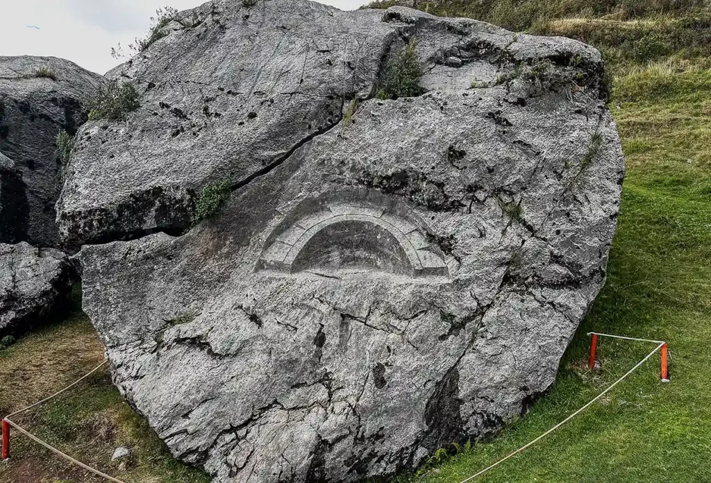
Q’enqo — the carved rock
Ten minutes further up. A limestone outcrop riddled with channels, a zigzag groove that gives the site its name — q’enqo, zigzag or labyrinth — and a subterranean chamber with an altar cut from the living rock.
This is the clearest surviving example of what a huaca actually was. Nothing was built here. The rock itself was the sacred thing, and working it was the act. If you only understand one site on this route, make it this one.
30 to 40 minutes. Go into the cave; most people don’t.
Puka Pukara — the red fort
Reddish stone on a rise beside the road. Usually described as a checkpoint or waystation controlling the route toward Antisuyu and the jungle.
Less spectacular than the others, and useful precisely for that: it shows the network mixed the administrative and the sacred without much of a boundary. A waystation was still on a ceque.
15 to 20 minutes is plenty.
Tambomachay — the water shrine
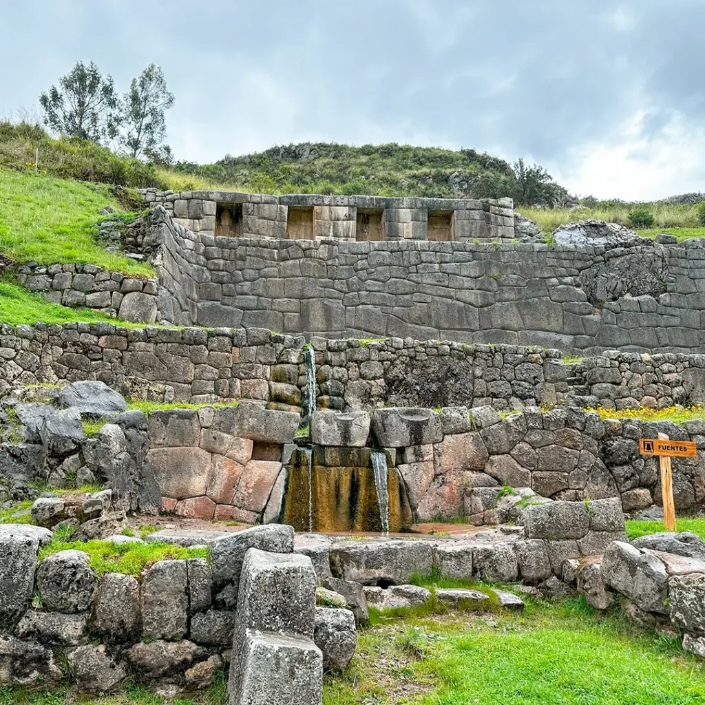
The furthest and highest, at around 3,765 m. A three-tiered structure where a spring emerges and is channelled through cut stone into a sequence of falls.
It still runs. Five hundred years on, exactly as engineered.
Water shrines recur throughout Inca sacred architecture — the fountains at Wiñay Wayna on the Inca Trail, the sixteen linked fountains at Machu Picchu. Tambomachay is where you see the principle in its purest and most compact form.
20 to 30 minutes. It’s small, and worth sitting at.
The Sacred Sites Cusco Walking Route: The Practical Version
The hybrid day, with times and costs.
| 8:30 | Coricancha opens. Walk from the Plaza, five minutes |
| 8:30–9:30 | Coricancha |
| 9:45 | Taxi from the centre to Tambomachay, ~S/10, ~20 min |
| 10:15–10:45 | Tambomachay |
| 10:50–11:10 | Puka Pukara — about 5 minutes’ walk from Tambomachay |
| 11:10–12:00 | Walk down to Q’enqo, roughly 45 minutes along the roadside |
| 12:00–12:40 | Q’enqo |
| 12:55 | Cristo Blanco, about 15 minutes on — worth the detour for the view |
| 13:05–14:30 | Sacsayhuamán, 5–10 minutes from Cristo Blanco |
| 14:50 | Walk down into Cusco, about 20 minutes |
Total: five to six hours, including site time. One walker’s tracker logged 16 km across a day like this — most of the distance is the roadside stretch between Puka Pukara and Q’enqo.
The shortcut worth knowing: a local colectivo runs between Puka Pukara and Q’enqo for S/1–2 and removes the longest and least interesting section. Nobody will think less of you.
Start earlier if you can. The sites are emptiest before ten and after three.
What the Road Actually Looks Like
Nobody mentions this part, and it’s the part that surprises people.
The stretch between Tambomachay and Q’enqo follows the Cusco–Pisac highway. It is a real road with real traffic — combis, tour minibuses, trucks heading for the valley — and for long sections there is no pavement, only a gravel verge a metre or so wide.
- Walk facing the traffic. Downhill means you’re on the left going toward the city, and drivers coming round the bends need to see you before they’re on you.
- The surface alternates between asphalt shoulder, packed dirt and loose stone. It is not technical, but it is not a footpath either, and in the wet the verge turns to red mud that will end up on everything.
- Dogs. There are farm dogs along this section. Most are indifferent. A few bark and follow for thirty metres and then lose interest. Don’t run, don’t stare at them, keep walking. Picking up a stone — or pretending to — is the local reflex and it works.
- Vendors and horses. You’ll be offered horseback rides, alpaca photos and knitwear along the way. Prices are negotiable and nobody minds a polite no. If you do take a photo with someone’s animal, S/2 to S/5 is the normal courtesy.
- Toilets. There are facilities at Tambomachay and at Sacsayhuamán, both usually S/1 and both worth using when you find them, because there is nothing in the middle.
- Food. Small stalls near the Tambomachay entrance sell drinks, crisps and sometimes empanadas. For anything more substantial you’re waiting until you’re back in San Blas. Carry your own lunch if you plan to sit at Sacsayhuamán for an hour and a half, which you should.
Shorter Versions, If You Haven’t Got a Day
Three honest cut-downs, in the order we’d recommend them.
- The three-hour version. Taxi to Q’enqo, walk to Cristo Blanco and Sacsayhuamán, descend into the city. You lose the water shrine and the red fort, keep the two sites that carry the most, and the boleto still pays for itself.
- The two-hour version. Coricancha in the morning, Sacsayhuamán in the afternoon, taxi both ways. Not a walk at all, but it gives you the centre and the largest complex, which is the minimum that leaves you with a coherent picture.
- The sunset version. Walk up to Sacsayhuamán at around four, when the tours have gone and the light on the walls goes orange. Two hours, no crowds, and a downhill walk back with the city lighting up below you. Check the closing time first — it varies seasonally and guards clear the site.
The Full Uphill Version
If you’re properly acclimatised and want to walk the route in the direction the system was counted, it’s a good walk.
- From the Plaza de Armas: take Calle Suecia uphill, right onto Calle Huayna Pata, then Calle Resbalosa — a pedestrian street of stone steps — up to the San Cristóbal viewpoint. Continue on the road another five or six minutes to the first control booth.
- About 45 minutes, all of it uphill, gaining roughly 300 m from the Plaza.
- Be honest with yourself about the altitude. This is a steep climb starting at 3,399 m. If you arrived in Cusco yesterday, don’t. Our guide to altitude and acclimatisation covers why, and the 7-day Cusco itinerary shows where a day like this sensibly fits.
- A good compromise: walk up to Sacsayhuamán, spend the morning there and at Q’enqo, then take a colectivo or taxi up to Tambomachay and walk back down. You get the ascent without the full 10 km.
- Other ways up: taxi from the centre, S/10–15. Combi to Cristo Blanco, around S/2, then five to ten minutes on foot. Taxis are scarce at the sites themselves, so plan the return.

Tickets: What You Need and What You Don’t
The part that costs people money and time.
The Boleto Turístico
The four sites above Cusco — Sacsayhuamán, Q’enqo, Puka Pukara and Tambomachay — are only accessible with the Boleto Turístico. There is no individual ticket for them.
Boleto Turístico General: around S/130 for foreign adults, valid 10 days, covering sixteen sites. S/70 for foreign students with valid ID.
Partial circuit covering the four ruins: around S/70 for foreign adults, valid one day.
Children 0–9 go free; ages 10–17 qualify at the student rate with ID.
If these four sites are all you want, buy the partial. If you’re also doing the Sacred Valley — Pisac, Ollantaytambo, Chinchero, Moray — the general ticket usually works out better.
Note on circuit numbers: operators cite different numbers for the circuit covering the four ruins. Ask for “the circuit with Sacsayhuamán” at the counter rather than trusting a number you read online, including this one.
Where to buy, and the cash problem
COSITUC’s central office is on Av. El Sol 103, in the Galerías Turísticas, open daily roughly 07:30 to 18:00. You can also buy at the site entrances.
It is cash only, in soles, and there is no online purchase. Bring notes. This catches out more visitors than anything else on this page.
The Coricancha is separate — probably
Here is a genuine muddle, and we’d rather flag it than pretend.
The Coricancha temple, inside the Santo Domingo convent, has its own admission — around S/15 for foreign adults, S/8 for students, free under 10. Hours are roughly Monday to Saturday, 8:30 to 17:30, closed Sunday.
The confusion comes from the Museo de Sitio del Qorikancha, a separate underground archaeological museum off Av. El Sol, which is on the Boleto Turístico. Two different places, similar names, different tickets — and some sources conflate them.
Practical advice: budget S/15 for the temple and don’t count on the boleto covering it. And go on a weekday, because Sunday closing surprises people.
What You Can Do Without a Ticket
More than you’d expect, and worth knowing if you’re on a tight budget or a short stay.
- Cristo Blanco and the viewpoint beside it — free, and the best wide view over Cusco.
- San Cristóbal viewpoint on the way up — free.
- The walk itself — the road between the sites, the stonework visible from outside the perimeters, and the general geography, all free.
- The Coricancha’s exterior walls — the great curved wall on Calle Ahuacpinta and along Av. El Sol is visible from the street, and it’s some of the finest stonework in the Andes.
- Sacsayhuamán’s outer areas are fenced and ticketed; don’t try to slip in. Guards are present and the fine is not worth it.
- And the quieter sites beyond the circuit: Inkilltambo in the ravine east of the city, Salonpunku (the Temple of the Moon) past Sacsayhuamán, and Chakan to the west are generally free or nearly so, and on a weekday you may have them alone. Our piece on unbeaten paths in Cusco covers that territory.
Altitude, Weather and Timing
- Altitude. The route runs from 3,399 m to about 3,765 m. Not extreme by Cusco standards, but the climb out of the city is steep and the whole day is above 3,300 m. Two to three nights of acclimatisation before you attempt the uphill version.
- Sun. There is almost no shade on this route. High-factor sunscreen, brimmed hat, sunglasses. The UV at 3,700 m is fierce and people underestimate it constantly.
- Rain. Afternoon showers are the pattern from November to March. Start early and you’ll usually be finishing as it arrives.
- Cold. Once the sun drops behind the ridge the temperature falls fast, even in dry season. Carry a layer regardless of how warm the morning is.
- Crowds. The four ruins are busiest between 10 and 14, when the bus tours cycle through. First thing or after three is noticeably calmer.
- Best months. April to October for reliable weather. May, September and October for the best balance of conditions and quiet.
What to Bring
- Cash in soles — for the boleto, the Coricancha, taxis, colectivos and water. Card acceptance is minimal.
- Your passport — required for the student rate and sometimes checked at entry.
- Water, more than you think for a day at altitude.
- Sun protection.
- A warm layer for the descent.
- Shoes with grip — the stone is polished and slick when wet.
- Snacks. There are vendors at Tambomachay and Sacsayhuamán and nothing much in between.
Mistakes We See
Doing it uphill on day two in Cusco. A 300 m climb starting at 3,399 m when you landed yesterday.
Arriving without cash. The boleto is cash only and there’s no ATM at the sites.
Assuming the Coricancha is on the boleto. Budget separately.
Going to the Coricancha on a Sunday. Closed.
Taking the standard bus tour and expecting explanation. Three hours, four stops, no system.
Walking the Puka Pukara–Q’enqo road stretch when you’re already tired. Take the colectivo.
Skipping Q’enqo’s cave because the entrance looks like nothing.
Buying the general ticket for one day’s sightseeing. The partial is half the price.
Making Sense of What You’re Looking At
A walking route gives you the geography. It doesn’t automatically give you the meaning, and the honest position is that a morning among stones can leave you impressed and none the wiser.
Two things help.
- Read the system first. Our guide to the power places of Cusco explains the ceques and what a huaca actually was; the piece on the Apus covers the mountains these sites were oriented toward. Thirty minutes of reading changes what the carved channels at Q’enqo look like.
- Or sit with someone who carries the practice. The tradition that produced this geography did not end — it is practised an hour away in Chinchero. A coca leaf reading is an hour, from $70, and our guide to despacho offerings explains what the offerings made at places like these actually contained.
- One boundary. Don’t conduct your own ceremony at these sites. They are protected archaeological areas administered by Peru’s Ministerio de Cultura through the Dirección Desconcentrada de Cultura de Cusco, with restrictions on offerings, fires and gatherings — and improvising a ritual from things you’ve read is exactly what the people who carry the tradition object to.
If you’d rather have a guide than a map, our city tour covers the four ruins, and our pages on the city of Cusco and the best sacred sites in the region give the wider cultural context this route sits inside.
Frequently Asked Questions
Can you walk to Sacsayhuamán from Cusco?
Yes. About 45 minutes uphill from the Plaza de Armas via Calle Suecia, Huayna Pata and the stone steps of Resbalosa, gaining roughly 300 m.
How long does the full walking route take?
Five to six hours including time at all four sites, plus the Coricancha in the morning.
Should I walk up or take a taxi and walk down?
Taxi to Tambomachay (~S/10) and walk down, unless you’re well acclimatised and want the climb.
Do I need the Boleto Turístico?
Yes for the four ruins — there’s no individual ticket. Around S/70 for the partial circuit covering them, or S/130 for the ten-day general ticket.
Is the Coricancha included?
No — budget around S/15 separately. The Museo de Sitio del Qorikancha, a different place, is on the boleto.
Can I pay by card?
No. The Boleto Turístico is cash only, in soles.
What are the Coricancha’s hours?
Roughly Monday to Saturday, 8:30 to 17:30. Closed Sunday.
How far apart are the four ruins?
Tambomachay to Puka Pukara is about 5 minutes on foot; Puka Pukara to Q’enqo roughly 45 minutes downhill along the road; Q’enqo to Sacsayhuamán about 20–25 minutes via Cristo Blanco.
Is there a shortcut on the long road section?
Yes — a colectivo between Puka Pukara and Q’enqo for S/1–2.
What can I see for free?
Cristo Blanco, the San Cristóbal viewpoint, the Coricancha’s exterior walls, and the quieter sites at Inkilltambo, Salonpunku and Chakan.
How acclimatised do I need to be?
Two to three nights minimum for the uphill version. The taxi-and-descend version is manageable sooner.
Do It in This Order
Coricancha at opening. Taxi to the top. Walk down through Tambomachay, Puka Pukara, Q’enqo and Sacsayhuamán, and into the city on foot as the light goes.
You’ll have started at the centre, which is the only way the geography makes sense, and finished on the descent, which is the only way your legs will thank you.
Put a hand on the carved channels at Q’enqo on the way past. Somebody cut those so that liquid would run in a particular direction, and they were not making a decoration.
Tell us your dates and we’ll fit this into a wider few days.
Ticket prices, circuit numbers and opening hours change and are published inconsistently by third parties; figures here were current at the time of writing and should be confirmed at the COSITUC office or the site entrance. Archaeological sites around Cusco are administered by the Ministerio de Cultura through the Dirección Desconcentrada de Cultura de Cusco; offerings, fires and gatherings at these sites are restricted. Walking at altitude carries a risk of altitude illness regardless of fitness — allow time to acclimatise and consult your physician if you have any cardiac or respiratory condition.